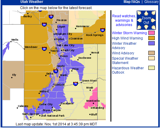
A screen capture of theNational Weather Serviceforecast for Utah on November 1, 2014.
UTAH – From high wind warnings to winter weather advisories, the majority of Utah is under some form of weather advisory issued by the National Weather Service Saturday.
Large portions of Utah are under a high wind warning and a hazardous weather outlook while other areas have winter weather and wind advisories in place.
The map above depicts the areas and their respective advisories, click here to visit the National Weather Service for the most up to date information.
The high wind warning is expected to remain in effect until 10 p.m. Saturday, and parts of Salt Lake and Tooele valleys and the Great Salt Lake Desert will see high winds. Winds in excess of 60 mph are expected, and the winds have caused several high-profile vehicles to tip over. Officials urge semi trailers and other high-profile vehicles to avoid that portion of I-80 until the wind dies down, click here for details and photos.
Click here for the complete wind warning from the NWS.
A less severe wind advisory is in effect for the areas just east of the high wind warning, and gusts of up to 55 mph are expected in the Sanpete and Sevier valleys, the Wasatch Front and Cache Valley.
Click here for the complete wind advisory from the NWS.
The winter weather advisory applies to the mountainous areas of Utah, and high winds are also expected in those areas as well as accumulations of snow amounting to between 4 and 8 inches. The snowfall is expected to largely occur at elevations above 8,000 feet.
Click here for the complete winter weather advisory from the NWS.
A hazardous weather outlook is in effect for the western two-thirds of Utah and southwest Wyoming, and high winds and storms are expected. Click here for more details.
