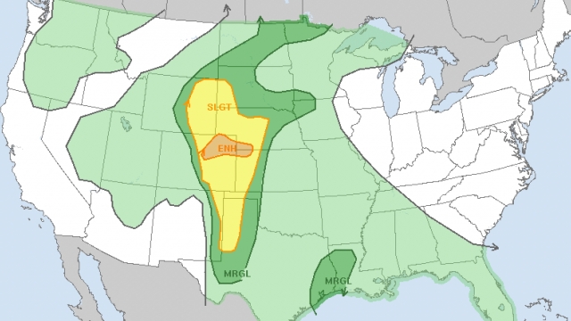
Houston is facing an increasing threat of flash flooding, while the central region of the United States is bracing for a surge in severe weather caused by an intense weather pattern. Benton County in Iowa has already experienced destructive hailstorms with pingpong-ball-size hail and strong winds. Similar severe storms are anticipated to produce large hail later today.
New Orleans also encountered flash flooding as storms swept across the Gulf Coast, resulting in the rapid inundation of an underpass. Emergency crews had to rescue two individuals who were trapped in a car immobilized by the floodwaters.
The National Weather Service satellite reveals a weather system progressing along the Texas Gulf Coast, aiming directly for Houston. The city is projected to receive approximately 4 inches of rain on Wednesday. Due to its low-lying nature, Houston is prone to flooding even with moderate rainfall, leading officials to anticipate water rescues as people attempt to drive through the flooded areas. Another area of concern on Wednesday is Denver, where powerful thunderstorms are expected to pass through.
In total, around 17 million Americans in the risk zones spanning from the Canadian border through the Great Plains to Mexico are under threat. The regions with the highest risk include parts of Wyoming, Nebraska and Colorado, as well as the panhandles of Oklahoma and Texas. These areas are likely to experience severe storms, large hail, and possibly a few tornadoes.
SEE MORE: Researchers predict 'slightly below-average' 2023 hurricane season
Trending stories at Scrippsnews.com


